- Joined
- Jan 1, 2015
- Messages
- 6
- Reaction score
- 0
I'm trying to track down a flyaway P2V+ 3.0, and having some confusion with my telemetry... could use help as we search for the drone. I was operating it in Cambridge, MA at a large park, but apparently it ran off course (big gusts of wind started up) and RTH did not work despite having a lot of battery left. As soon as I lost WIFI, i initiated Naza RTH, and after a few seconds more of not seeing the drone powered the transmitter off entirely. RTH had been tested before on the field easlier in the day so I was feeling pretty confident it would come back. It never did. 
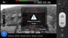
Attached is the last photo transmitted.
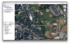
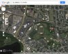
However, the last GPS coordinates it shows do not match to the photo at all.. Any ideas?
Is there a device I can buy that will record telemetry to a file? Really hoping I can find my P2V..
Attached is the last photo transmitted.
However, the last GPS coordinates it shows do not match to the photo at all.. Any ideas?
Is there a device I can buy that will record telemetry to a file? Really hoping I can find my P2V..