

- Joined
- Apr 3, 2016
- Messages
- 388
- Reaction score
- 123
- Age
- 68
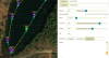
I've created a waypoint mission using Litchi. It's an overwater flight of a local freshwater pond. Litchi reports it's at 212 ft MSL. I've got the Above Ground and Use Online Elevation settings checked in Litchi. As I always do, I've exported the Litchi mission into a KML file to load into Google. The paths for the file enter the water in Google earth at the beginning and end of the flight even though the Litchi alt is set to 42'. What would the result of the flight be? Anyone? Screen shots attached:
View attachment 112705View attachment 112705
View attachment 112705View attachment 112705
Attachments
Last edited:

") ...apologies in advance
...apologies in advance  )
)


