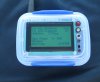
I've been using the Flytrex Live device on my P2 Vision+ and it has it's pros and cons. I'm using a T-Mobile micro-SIM card and when it gets a solid 2G link to the cell towers, it functions very well and my mission flight path is very accurate (+/- 10 meters). However, the obvious downsides are that the SIM requires a fee of some kind (lowest is $10 for 1 month/1GB data) and 2G coverage in the U.S. is spotty and being phased out by most wireless carriers by 2015-16. A new version of Flytrex Live will likely have a 3G/4G modem but who knows when it will be available.
Thus, I am looking for a non-GPS tracker to augment the Flytrex Live in locating a lost bird. I've heard about the Marco Polo Pet Tracker but it says maximum range of 2 miles and I have doubts about that. With a top speed of 33 MPH, my Vision+ could go into a flyaway right after takeoff and crash 8 or 9 miles away (once the battery runs out) and that's way beyond the Marco Polo range. You could start driving in the general direction of the flyaway and maybe the Marco Polo will pick up a signal eventually, but that seems like a lot of wishful thinking and dumb luck being involved. If you had half a dozen friends armed with Marco Polo locators you might have a decent chance of finding your bird, but how realistic is that?
I saw this YouTube video and it really piqued my interest. Dude was using a hand-held Yagi antenna and getting a UHF beacon signal (albeit weak) at 7.5 miles non-LOS !! That sounds like a foolproof way to find any lost bird, even one that goes into a flyaway on a fresh battery and ends up in the next county.")
[youtube]https://www.youtube.com/watch?v=rmc3gboiGkI[/youtube]
I was thinking that the combination of Flytrex Live + UHF beacon would make it virtually impossible to not find a lost Phantom. It would have to be in a very remote area where there are many square miles of no cell coverage and lots of obstructions like hills and heavy forest to block the UHF beacon signal. Luckily, there are very few places like that in Ohio and PA where I fly so I should be covered 99% of the time. For example, if I takeoff and the Flytrex Live locks on to 2G cell towers but then wanders into a dead zone and crashes into a tree, at least I can get a general direction the Phantom was flying by using the Flytrex Live data, and then walk/drive in that general direction and use the UHF beacon to home in on my bird.
All this makes me wonder why no one has invented an RF beacon that is coupled to a GPS receiver and transmits those coordinates back to a hand-held receiver, and thus eliminating the need to use a SIM-card enabled device? Tracking down a lost bird using a UHF beacon is still time-consuming because you have to stop repeatedly to get a ping and adjust your search path accordingly. It would be nice to have the GPS coordinates pinged back to your receiver so you can quickly use Google Maps to pinpoint it's location.
Thus, I am looking for a non-GPS tracker to augment the Flytrex Live in locating a lost bird. I've heard about the Marco Polo Pet Tracker but it says maximum range of 2 miles and I have doubts about that. With a top speed of 33 MPH, my Vision+ could go into a flyaway right after takeoff and crash 8 or 9 miles away (once the battery runs out) and that's way beyond the Marco Polo range. You could start driving in the general direction of the flyaway and maybe the Marco Polo will pick up a signal eventually, but that seems like a lot of wishful thinking and dumb luck being involved. If you had half a dozen friends armed with Marco Polo locators you might have a decent chance of finding your bird, but how realistic is that?
I saw this YouTube video and it really piqued my interest. Dude was using a hand-held Yagi antenna and getting a UHF beacon signal (albeit weak) at 7.5 miles non-LOS !! That sounds like a foolproof way to find any lost bird, even one that goes into a flyaway on a fresh battery and ends up in the next county.
[youtube]https://www.youtube.com/watch?v=rmc3gboiGkI[/youtube]
I was thinking that the combination of Flytrex Live + UHF beacon would make it virtually impossible to not find a lost Phantom. It would have to be in a very remote area where there are many square miles of no cell coverage and lots of obstructions like hills and heavy forest to block the UHF beacon signal. Luckily, there are very few places like that in Ohio and PA where I fly so I should be covered 99% of the time. For example, if I takeoff and the Flytrex Live locks on to 2G cell towers but then wanders into a dead zone and crashes into a tree, at least I can get a general direction the Phantom was flying by using the Flytrex Live data, and then walk/drive in that general direction and use the UHF beacon to home in on my bird.
All this makes me wonder why no one has invented an RF beacon that is coupled to a GPS receiver and transmits those coordinates back to a hand-held receiver, and thus eliminating the need to use a SIM-card enabled device? Tracking down a lost bird using a UHF beacon is still time-consuming because you have to stop repeatedly to get a ping and adjust your search path accordingly. It would be nice to have the GPS coordinates pinged back to your receiver so you can quickly use Google Maps to pinpoint it's location.