

You are using an out of date browser. It may not display this or other websites correctly.
You should upgrade or use an alternative browser.
You should upgrade or use an alternative browser.
Where to buy GCP plastic target ?
- Thread starter PeteM
- Start date
Sorry, if you were located in North America I would probably be able to help you out.
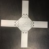
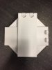
We designed and 3D printed there, they have dual hinges for easy storage. They are 19.5'' x 19.5'' and can be printed in any colour or spray painted as well.
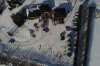
This attached image was taken at 400ft AGL with the Phantom 4 Pro.
We designed and 3D printed there, they have dual hinges for easy storage. They are 19.5'' x 19.5'' and can be printed in any colour or spray painted as well.
This attached image was taken at 400ft AGL with the Phantom 4 Pro.
Attachments
- Joined
- Feb 3, 2017
- Messages
- 22
- Reaction score
- 6
- Age
- 89
They are used for 3D mapping, geo-referencing the dataset afterwards.Duh . . . what are such targets used for?
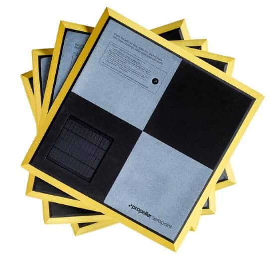
Something like this (just heavy plastic with no "smart tech" inside) would be perfect.

Actually any clearly visible feature, such as the corner of a parking lot or structure can serve as a GCP. Critical thing is to be able to accurately survey the area so that you know'exactly' where the GCPs are in real world space.
- Joined
- Apr 24, 2014
- Messages
- 72
- Reaction score
- 7
Sorry, if you were located in North America I would probably be able to help you out.
We designed and 3D printed there, they have dual hinges for easy storage. They are 19.5'' x 19.5'' and can be printed in any colour or spray painted as well.
This attached image was taken at 400ft AGL with the Phantom 4 Pro.
What an ingeniuos idea!!
Hope you don't mind me asking but I have a P4 Pro also but not put it to the task of Survey work yet. Still using a p3 Pro and a custom Steadidrone Mavrik. What sort off accuracy's are you able to achieve with the P4 pro?
Hey Jimmy,
I surveyed the GCPs using Trimble RTK, I also took random measurements on the ground (no GCP) with the RTK throughout the job area as a secondary checks in the latter step. I processed the data using Pix4D, I then bring in the ground shots that were measured into Cloud to Cloud software to verify the accuracy of the UAS survey. I can confidently say the accuracy of this survey is +- 4cm vertical.
I surveyed the GCPs using Trimble RTK, I also took random measurements on the ground (no GCP) with the RTK throughout the job area as a secondary checks in the latter step. I processed the data using Pix4D, I then bring in the ground shots that were measured into Cloud to Cloud software to verify the accuracy of the UAS survey. I can confidently say the accuracy of this survey is +- 4cm vertical.
Attachments
Actually any clearly visible feature, such as the corner of a parking lot or structure can serve as a GCP.
So far I have done so, but I realize that with visible targets the process would be easier.
I purchased 18 inch floor tiles from the local hardware store. Bought white, and painted opposite corners black, just like the "smart tiles" that you posted pics of. Drilled a small hole in the center to see the control point beneath it. They work well and are very visible in aerial photos. Price was about $2.50 per tile.
Most of our targets are disposable one time use. Our quick and easy is pizza circles made of white cardboard bought by the case. (18"x100 on ebay for $35 = $0.35 each) We nail them down with a 60d nail and shiner and use a 4" pvc sewer pipe as a template to paint a black dot in the center. I find the dot works great when using the GCP editor in Pix4D.
In town, we paint manholes and water valves as circles with a dot using water based upside down spray paint. When they won't let us paint targets, we print out 11"x17" paper targets and use spray adhesive to hold them down on sidewalks or pavement. Easy to remove when done.
For larger permanent projects we make targets out of 9"x24" strips of Dollar Tree Foam board. We put 1/2" grommets in the ends and paint a coat of clear polyurethane on both sides. We then arrange them around the GCP in crosses or "T"s. I have some of these targets that have been out over a year. This costs $1 for a 4' target plus grommets. We buy them by the 5000 for a few dollars.
For high altitude photography when we need larger targets, we buy sheets of 1/4" fluted polypropylene at Home Depot and cut it 9"x48". We put a grommet in each end and nail them down in a cross. Very weather resistant and reusable too. At $16 per sheet, this works out to less than $5 for a 8' target.
Would you be willing to share the STL files for your targets? They look great.
- Joined
- Mar 18, 2017
- Messages
- 7
- Reaction score
- 0
- Age
- 57
Thomas,
I assume the accuracy is mostly dependent on the accuracy of your ground control points/coordinates obtained by your RTK?
I'm a newbie and am interested in the photogrammetry aspect (mainly horizontal accuracy). I am a forestry consultant and, at times, need current aerial photos.
I assume the accuracy is mostly dependent on the accuracy of your ground control points/coordinates obtained by your RTK?
I'm a newbie and am interested in the photogrammetry aspect (mainly horizontal accuracy). I am a forestry consultant and, at times, need current aerial photos.
The horizontal accuracy would be in the 3-5cm rangeThomas,
I assume the accuracy is mostly dependent on the accuracy of your ground control points/coordinates obtained by your RTK?
I'm a newbie and am interested in the photogrammetry aspect (mainly horizontal accuracy). I am a forestry consultant and, at times, need current aerial photos.
Similar threads
- Replies
- 2
- Views
- 3K
- Replies
- 3
- Views
- 2K
- Replies
- 3
- Views
- 1K
- Replies
- 3
- Views
- 2K


