AirMap is pretty sweet so +1 for that app. I almost wish it didn't exist as it makes it too easy to see where you can't fly :/ haha
I'm in SF Bay Area as well and in doing my own research since I got my
P4P I've noticed it's tricky with all the airports, national recreation areas, parks, populated areas, etc., lots of locations are questionable or have some sort of advisory. Pretty much the whole city is off limits since you can't fly over people, and lots of the coastal areas in SF is National Park land, so no go. I've been hitting state parks in the North Bay, which are largely unregulated as of yet, but lots of the coast there (Marin Headlands, Point Reyes, etc.) is national parkland so sort of a bummer. There are some large parks in the East Bay that don't have major restrictions as well. If you're in the South Bay you're sorta sol as there's a million airports down the Peninsula and, San Jose and Silicon Valley, though you can head West towards Half Moon Bay and Pescadero and there's plenty of open airspace.
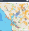
Just took a quick peek at the AirMap, see the attached screenshot for all the advisories across the Bay Area, you can pepper in some fly time here and there just gotta go find it
")
If you're going to fly commercial for a professional job you can always apply for a permit/exemption, but for tooling around check the AirMap and have fun exploring!
Hope that's helpful. Anyone else have SF Bay Area location ideas/tips/suggestions?