- Joined
- May 4, 2021
- Messages
- 3
- Reaction score
- 0
- Age
- 39
Hello,
I am starting to work with a P4 Multispectral to use in Pix4D Fields, therefore I am using the Pix4Dcapture to get the images from the missions (it seems that this app provides more effectiveness to cover the area in terms for flight time/battery than GSP).
During a test run, I performed a flight over the same 145 acres at 330 ft. and 165 ft. After finishing the mission the app displayed a total of 450 and 1679 images (points) for each mission respectively.
When I came to process the images, the total of images in the SD card was very low, just 79 and 360 points (not counting the pictures from all the bands), so a lot of information was lost and of course the reconstruction of the orthomosaic in Pix4D fields, although it was done, was logically full of gaps.
During the mission I also noted some gaps, where it seems some pictures were not taken.
The SD card was new and complying with all the specifications. No errors were shown during the mission.
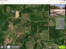
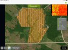
To note, during the mission the furthest point from home was less than 4000 ft. However the app was showing slightly over 19000 ft. away, as can be observed in the image of the mission. In the next image it can be noted that the remote control is being recognized so far from where I was (therefore 19000 ft away)
If I fly the mission with GSP, I spend more battery, but I get all the images, but the same error with the remote control is displayed.
What am I doing wrong? Thanks for any assistance you may provide!
Best.
I am starting to work with a P4 Multispectral to use in Pix4D Fields, therefore I am using the Pix4Dcapture to get the images from the missions (it seems that this app provides more effectiveness to cover the area in terms for flight time/battery than GSP).
During a test run, I performed a flight over the same 145 acres at 330 ft. and 165 ft. After finishing the mission the app displayed a total of 450 and 1679 images (points) for each mission respectively.
When I came to process the images, the total of images in the SD card was very low, just 79 and 360 points (not counting the pictures from all the bands), so a lot of information was lost and of course the reconstruction of the orthomosaic in Pix4D fields, although it was done, was logically full of gaps.
During the mission I also noted some gaps, where it seems some pictures were not taken.
The SD card was new and complying with all the specifications. No errors were shown during the mission.
To note, during the mission the furthest point from home was less than 4000 ft. However the app was showing slightly over 19000 ft. away, as can be observed in the image of the mission. In the next image it can be noted that the remote control is being recognized so far from where I was (therefore 19000 ft away)
If I fly the mission with GSP, I spend more battery, but I get all the images, but the same error with the remote control is displayed.
What am I doing wrong? Thanks for any assistance you may provide!
Best.